Why is Geography Important
Jan 14, 2026
Study Hub
Some may find geography uninteresting. Yet, it holds lessons for daily life. It’s not just a subject that you either...
When you are considering a degree in geography, you will quite frequently come across the term “physical geography.” This discipline establishes itself by paying attention to the way natural systems on earth operate and their implication to day to day life. It examines climatic conditions, topography, rivers, glaciers, oceans, and natural disasters, and the instruments employed to measure and map the processes.
Even though it’s random, I’ve been prepping the integral calculator on our site, and I thought about this question. Here, I argue what physical geography is about, what students earn on the degree, what skills they develop, and what forms of careers they pursue after they complete their degree.
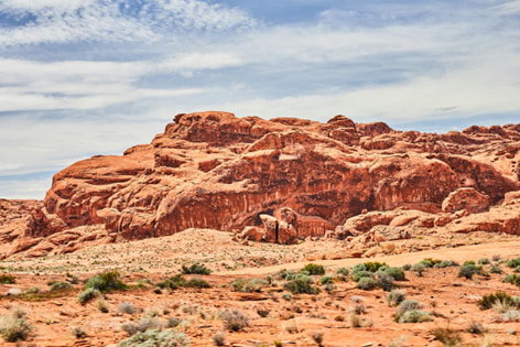
Physical geography has a number of fields that specialize in the way in which the natural systems operate. All the areas examine another section of the earth, whether it is climate, rivers, or ecosystems. The key fields, which study and investigate them, and their application in real work are presented in the table below.
| Physical Geography Area | What It Studies | Common Tools | Where It Is Used |
|---|---|---|---|
| Climatology | Climate patterns and weather | Climate data, models, GIS | Climate risk analysis, forecasting |
| Geomorphology | Landforms and surface changes | Field surveys, satellite images | Erosion control, landslide planning |
| Hydrology | Rivers, groundwater, water flow | Fieldwork, stream gauges, GIS | Water management, drought planning |
| Glacial Studies | Glaciers, ice loss, snow | Satellite data, remote sensing | Sea level studies, water supply |
| Biogeography | Ecosystems and species distribution | GIS, field sampling | Conservation, habitat mapping |
| Natural Hazards | Floods, storms, earthquakes | Hazard maps, field data | Emergency planning, risk analysis |
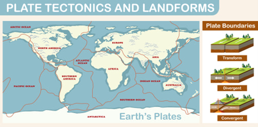
Physical geography focuses on Earth’s natural systems and how they shape the planet. It looks at climate, landforms, soil, rivers, oceans, and the atmosphere, along with the processes that change them over time. According to educational material from the National Geographic Society, physical geographers study topics such as seasons, climate patterns, water systems, and the structure of the landscape. These topics are often grouped into fields like climatology, geomorphology, hydrology, biogeography, and oceanography.
This field relies on measurement and spatial analysis rather than simple observation. Tools such as satellite data, remote sensing, and geographic information systems (GIS) help researchers map and analyse patterns across large areas. For example, global climate data now comes from thousands of weather stations and more than 20 active Earth-observation satellites. By combining these datasets with mapping tools, physical geographers can track glacier loss, river changes, or shifts in ecosystems over time.
A physical geography degree is usually part of a Geography department, often within a College of Arts and Sciences. Many universities offer both Bachelor of Arts (BA) and Bachelor of Science (BS) options. The difference often relates to focus. A BS program normally includes more natural science, data analysis, and laboratory or fieldwork. A BA program may include more courses linked to society, policy, or regional studies. The exact structure depends on the university and its curriculum.
Typical elements in many physical geography programs include:
Physical geography often connects with human geography as well. For example, a floodplain belongs to the natural landscape, yet flood risk depends on housing patterns and urban planning. This link between natural systems and human decisions is one reason the subject remains relevant in many fields.
Many university pages about geography explain theory but spend less time on practical skills. Physical geography focuses on work with environmental data and natural systems. Students study climate patterns, rivers, landforms, and ecosystems. They use maps, satellite data, and field measurements to analyse how processes change across locations.
According to data from the U.S. Bureau of Labor Statistics, the median pay for the job title “geographer” reached about $97,200 per year in 2025, which shows that spatial analysis and environmental data skills have clear use in the labour market.
| Skill | Use at Work |
|---|---|
| GIS and mapping | Spatial analysis and planning support |
| Field methods | Environmental monitoring and site assessments |
| Hazard analysis | Risk assessment and emergency planning |
| Data analysis | Analyst and research support roles |
| Report writing | Technical reports and documentation |
These skills help students move from raw data to clear conclusions. A task often starts with measurements or spatial data, then continues with analysis that explains patterns and possible impacts. Work like this appears in environmental agencies, research groups, planning offices, and water management projects. Digital tools help organise this process. For example, EduBrain can help students store research sources, organise notes, and compare information from different datasets when studying topics such as climate, water systems, or natural hazards.
In the last few years, the field of physical geography has been given notice due to the fact that environmental processes directly impact the economies, cities, and infrastructure. Governments and communities have real costs brought about by climate change, floods, droughts, and storms. This needs more experts who can interpret environmental information, map hazards, and comprehend the interrelationship of the natural systems and human activity.
Some of the important characteristics of the recent disaster records indicate the magnitude of these effects:
These statistics are based on the information released by the National Oceanic and Atmospheric Administration. According to research organisations like the National Academies of Sciences, Engineering, and Medicine, geography aids in the examination of the connection between natural processes and human systems. Physical geographers are interested in interactions between hazards and settlement, infrastructure, and land use. Their tasks tend to involve environmental science, spatial analysis, and making a decision using incomplete information.
Universities tend to break the topic down into some key subjects, which examine climate, landforms, water systems, and ecosystems. These spheres are closely interrelated. To take one example, global climate datasets now gather data on thousands of weather stations and satellites, and such information can assist researchers in analysing how the planet is changing in terms of its temperature, water cycles, and loss of ice.
The disciplines tend to collaborate in research and planning. In fact, glacier surveillance systems indicate that most mountain glaciers have lost more than a quarter of their mass since the end of the 20 th century, which impacts river flow and water supply in parts of the world. Such data assists the governments and research organisations in planning water management, climate adaptation, and environmental protection.
Physical geography graduates frequently take up similar jobs in which spatial data and environmental analysis are applied. Some of them have jobs as GIS analysts, environmental analysts, hydrology technicians, research assistants, planners, and in government agencies.
According to the U.S. Bureau of Labor Statistics, there are still jobs associated with a geographical area that keep appearing annually, and approximately 100 vacancies are generated yearly to fill the job title of geographer. There are numerous additional positions in the areas where the tools and knowledge are similar, particularly the ones pertaining to GIS, environmental monitoring, and hazard analysis.
The most common career possibilities are:
The National Geographic Society gives educational content that clarifies the nature of the field. Physical geographers examine the natural systems, which include climate, soil, rivers, land forms, and the oceans. This information enables organisations to know the change in the environment and make plans using spatial information.
Lots of students seek universities where physical geography is available, but rankings rarely tell you much about the way a program functions. The next step that should be done is to examine the courses and training of each university. When you look at the course plan, fieldwork, and research projects, it allows you can see what the program is going to teach you. Comparison steps:
These actions will aid you in making comparisons of universities in a systematic manner. Tools like EduBrain will assist students in sorting notes, summarising research, and assist with the homework related to environmental information or mapping techniques when studying geography topics and preparing assignments.
Physical geography may be a good decision when students are fond of natural science and desire to apply it in practice. The topic revolves around systems like climate, water, waterfalls, and environments. Students tend to use environmental data, maps, and GIS, etc. Numerous activities are based on interpreting information and how the process of nature impacts places and communities. In the degree, practical work in the form of maps, brief reports, field notes, or research projects is generally produced by the students.
These are some of the examples utilized to demonstrate what skills were acquired throughout the program. In the long term, this work can create a portfolio that helps in future appointments in the area of environmental research, planning, and managing water resources or spatial analysis.

Some may find geography uninteresting. Yet, it holds lessons for daily life. It’s not just a subject that you either...
In a world where technology increasingly defines our interactions, using AI for flirting is no longer a futuristic concept —...
Are you a high school student curious about chemistry? Many summer programs are available to help you explore this exciting...
